Modern Cartography
For everyone who wonders what I am doing here, apart from travelling and making half-hearted attempts at learning the Thai language: I contribute to the OpenStreetMap project!
What is OpenStreetMap? I will just cite what JOSM gives as a description:
“OpenStreetMap is a project aimed squarely at creating and providing free geographic data such as street maps to anyone who wants them. The project was started because most maps you think of as free actually have legal or technical restrictions on their use, holding back people from using them in creative, productive or unexpected ways.”
For places I travel to (and live), I track the path I took with my smartphone. These GPS traces can be uploaded to OpenStreetMap and serve as auxiluary data for people who map an area. The only thing one needs for that is a GPS-enabled smartphone or a GPS receiver.
The other way to contribute is to directly edit the map, taking as a source either Bing satellite imagery1, other copyright-free maps or the data gained by an own expedition into that area, using your own GPS traces with points of interests noted down. One can edit the map directly on www.openstreetmap.org through the “Edit” tab in the browser, just like Wikipedia.
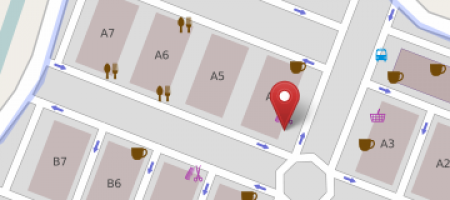
Here an example of a super-detailed part of map because this is where I have my flat ;-). I’d love to show you before-after images forgot to take a before-screenshot. So just let me tell you that the area shown in the screenshot just consisted of the canal there before I added the rest to the map.
This is what I’ve been doing. Check out the next blog article to see how such a GPS trace with points of interest noted down on my smartphone looks when I return from a survey.
1 That’s right, evil open-source fiend Microsoft supports OpenStreetMap by allowing OSM contributors to use their satellite imagery to be used as a source without imposing any limitations on the derived data. As opposed to Google by the way, who even just launched their own crowdsourcing application to enhance their maps by community contributions. On that topic, read this!
